This article contains affiliate links. Learn more in our affiliate disclosure.
We couldn’t miss this adventure during our road trip in Switzerland. It’s one of the most beautiful peaks around Interlaken overlooking mesmerizing Brienzsee Lake. It’s also a part of a famous and difficult Hardergrat Trail.
Augstmatthorn’s iconic ridge is becoming more and more popular. The narrow trail takes you up and down the hills while enjoying panoramic views on both sides. The steep slopes on both sides add some adrenaline.
Together with Oeschinensee, this is our favorite hike on the 10 day Switzerland itinerary which we followed during our trip. If you’re looking for another less popular ridge hike, check out Stoos Ridge Hike near Lucern.
Another incredible ridge hike we recommend is Schäfler Ridge and Seealpsee in the Appenzell Alps.
In this guide, we’ll tell you everything we know about the different hiking trails, Harder Kulm funicular, where to stay nearby, where to eat, and what to pack. We included many useful tips, which you should read before heading out!
Where is Augstmatthorn
The peak offers epic 360 views at 2136 m. It also overlooks a turquoise Lake Brienzsee near Interlaken, in the Berner Oberland region. The peak is a part of the Emmental Alps, and it’s almost in the middle of the challenging Hardergrat Trail (also known as Brienzergrat).
Save the location of Augstmatthorn to your Google Maps.

Best hotels in Interlaken
Check availability


Overview of hiking trails to Augstmatthorn
You can choose from three main trail options.
The easiest one which we personally recommend the most starts in Lombachalp. The whole trail is easy and comfortable, without too many steep sections. In general, it’s the cheapest, fastest, and easiest option.

Despite Lombachalp being an easy option, most people start from Harder Kulm. You can either hike or take a funicular to reach the trailhead. While it is not technically hard, it’s a long distance to cover.
The most beautiful section is between Suggiture and Augstmatthorn, which is a part of both trails mentioned above. So you won’t lose any views if you choose to hike from Lombachalp. But you won’t see Harder Kulm.
Another option is the Hardergrat Trail. It’s the most challenging option since it’s a very difficult trail only for experienced hikers. But if you’re an adventurous soul who loves mountains, you won’t be able to resist this one.

Below is a short overview of all the three trails mentioned above. The information provided is for the route there and back. The duration doesn’t include any stops at all, it’s a walking time. But Hardergrat is only hiked one way, from Brienzer Rothorn to Harder Kulm.
| Hike duration | Distance | Elevation | Difficulty | |
| from Lombachalp | 3 hours | 6.3 km | 576 m | easy |
| from Harder Kulm | 7.5 hours | 17 km | 898 m | medium |
| Hardergrat Trail | 12 hours | 20 km | ↑ 1200 m / ↓ 2100 m | very hard |

Key Highlights
⭐️ Duration: 3 – 12 hours
⭐️ Distance: 6.3 – 20 km
⭐️ Starting points: Lombachalp / Harder Kulm
⭐️ Where to stay: Interlaken
⭐️ Discount travel passes: Swiss Travel Pass | Half Fare Card | Bernard Oberland Pass | Jungfrau Pass
⭐️ Funicular tickets: Harder Kulm funicular tickets
⭐️ What to bring: Food, water, sunscreen, sturdy hiking shoes, camera
Hike from Lombachalp
Distance: 6.3 km
Elevation: 576 m
Duration: 3 h
Difficulty: easy
This trail to Augstmatthorn summit offers a very short distance since it’s only a 6.3 kilometre hike. During our trip, we spontaneously decided to hike up for the sunrise. So the only convenient option was to start from Lombachalp. But it’s a great choice if you’re short on time or if you want to save money on funicular.
Another reason why choose this trail is that it saves you a lot of energy while you still get the same views! The most beautiful section is a part of both the Harder Kulm and Lombachalp trails.

Getting to trailhead
If you decide on this hiking trail, you have to get to Lombachalp. The trail starts at Jägerstübli mountain hut.
By public transport
Unfortunately, there’s no direct bus available from Interlaken. If you decide to take a bus to Lombachalp, you have to first take bus 106 from Interlaken West to Habkern, Zäundli. It takes 23 minutes and costs 5.2 CHF.

From Habkern, you have to take bus 107 to Habkern, Lombachalp – Roteschwand. This section takes 25 minutes, but I don’t know the price.
Since the first bus to Lombachalp departs from Habkern at 08:30, you can take the bus from Interlaken at 08:04. This gives you 7 minutes to transfer. The buses are scheduled every hour.
The last bus departs from Lombachalp to Habkern at 17:00.
You can use the Swiss Travel Pass or Berner Oberland Pass on this route. You also get a discount with a Half Fare Card.

By car + Parking
We came here by our own car from Interlaken, but you can also rent one. However, car rental options are limited in Interlaken, so we recommend some of the bigger cities around. See our car rental in Switzerland guide for more details.
The road leading to Jägerstübli is well maintained, however, slightly narrow in some sections. The distance is under 15 kilometers and the journey only takes about 30 minutes.
When it comes to parking, we parked right next to Jägerstübli. The parking area is rather spacious and fits many cars. Bring some coins since you must pay using the automat. But if you don’t have any, you can also pay at the restaurant.
If you want to make sure you’ll have a parking spot, come early in the morning during high season.

Facilities on the trail
On this trail, you won’t find any facilities at all. This means there won’t be any restaurants or places to refill your water. The only place to get some food and drinks is Jägerstübli. Make sure to consider this when preparing for the day trip and pack everything you might need.
Trail description
Part 1: Lombachalp to Augstmatthorn
- Distance: 2.4 km
- Elevation: ↑ 568 m
- Duration: 1.5 h
The whole trail can be split into three sections. The first one is the uphill hike starting in Lombachalp. Physically, this is the hardest part. To catch the sunrise at the top we left the parking lot at around 4:30 am. We hiked in October when sunrise was at around 06:30.
We started walking upwards a very pleasant hill, which kept getting steeper and steeper with each step. In the beginning, we crossed a few meadows and muddy pools (due to rain). Before long, we got to a smaller ridge leading to the main Hardergrat Ridge.

After around 15 minutes of walking along the ridgeline heading straight up, the path got even steeper. This is where we started to traverse the hill and walk in zig-zags. We met plenty of Ibex hanging around. It was kind of scary at night since all we could see were their eyes shining bright.
Soon we reached the main ridgeline – Hardergrat. Our goal was only around 10 more minutes from here. We read this section might take up to 2 hours, but we did it in a little over 1 hour. So I would suggest counting with 1.5 hours at a normal pace with few breaks.
If you plan to do this for sunrise, bring warm clothes. We were freezing at the top while waiting for the first rays of the sun.
Part 2: Augstmatthorn to Suggiture
- Distance: 1 km
- Elevation: ↑ 21 m, ↓ 75 m
- Duration: 0.5 h

This section is the main reason why you’re here. Honestly, we think it’s the most beautiful ridge in the Swiss Alps! Over the 1 kilometer, there’s almost no elevation. You simply follow the only trail that takes you along the epic ridgeline of Hardergrat towards Harder Kulm.
The views here are so irresistible we kept stopping every few minutes to take it all in. It’s literally a photographers’ paradise, with outstanding views all around and impossibly stunning trail. So instead of 30 minutes, it took us more than 1 hour.

Many sections are narrow with steep slopes on both sides. Honestly, I felt a bit uneasy in some parts. One wrong step and … Because of this, you might have trouble if you have a panic fear of heights.
While it sounds extremely dangerous, it really isn’t. As long as you have steady feet you’ll be fine. Even kids can definitely do this, but keep them close and hold their hands in those risky sections.

Part 3: Suggiture to Lombachalp
- Distance: 2.9 km
- Elevation: ↓ 525 m
- Duration: 1 h
The last part is basically just going down from the ridge to Lombachalp. We said goodbye to the mind-blowing ridgeline and started our descent. To be honest, I found it never-ending. The first minutes are steep and not as pleasant.

As we got closer to the parking lot, it kept getting better. Soon we were once again back on the same trail we took in the morning, crossing the same muddy pools. We enjoyed well-deserved fresh drinks at Jägerstübli and headed back to explore Interlaken.

Map of the trail from Lombachalp
Hike from Harder Kulm
Distance: 17 km
Elevation: 576 m
Duration: 7.5 h
Difficulty: medium
This is the classic Augstmatthorn hike.
The advantage of this hike is that you also get to visit Harder Kulm and ride a 100-year-old funicular. At the top, you can enjoy the views from a viewing platform or visit the restaurant. The building at the top looks like a beautiful castle.
The funicular ride is very popular, so you should expect a lot of crowds, especially during summer weekends. From the top, you can look forward to views of both Lake Thun and Lake Brienz, with Interlaken in between.

Getting to trailhead
Funicular to Harder Kulm
So most people would start this trail by taking a funicular. To get to the Harderbahn station, it only takes 15 minutes of walking from the center of Interlaken. You might first need to get to Interlaken Ost, which is across the river.
The first funicular leaves Interlaken at 9:10. The last one departs at 21:40 from late May until late September. Check the current schedule on Jungfrau official website. The travel time is only 10 minutes and departures are scheduled every 30 minutes.
You can use the , Berner Oberland Pass, or Jungfrau Pass on this route. You also get a discount with a Half Fare Card or Swiss Travel Pass, which provides unlimited train travel, boat and bus rides. You’ll get the cheapest price on GetYourGuide or Klook.
Don’t forget to buy tickets for Harder Kulm funicular.
Hike to Harder Kulm
- Distance: 4.1 km
- Elevation: ↑ 750 m
- Duration: 2.5 h
If you want to save some money, you can also hike up instead of taking the funicular. From the lower station, you can simply follow the red and white marked trail until you reach the top. It’s a 4.1 kilometer hike though. So if you decide to skip the funicular both ways, you’ll add a lot of kilometers and elevation to your hike.
Because of this, we don’t really recommend doing it this way. If you’re a fit hiker, go ahead. But the average person might have a hard time hiking from Interlaken. It’s a steep trail that leads you in zig-zags through the forest.

Facilities on the trail
Just as a hike from Lombachalp, you won’t find any facilities on the trail. The last place to get some drinks or food is Harder Kulm. Therefore, make sure you bring enough water with you!
Trail description
Part 1: Harder Kulm to Suggiture
- Distance: 7.3 km
- Elevation: ↑ 804 m, ↓ 48 m
- Duration: 3 h
The only reason why I split this hike into two parts is the huge difference in views.
As you depart the upper station, follow the dirt trail which soon takes you to forests. As soon as you’re surrounded by the trees all the views disappear. The first 5 kilometers (1.5 hours) only offer an occasional glimpse of the lakes.
What complicates the hike is also the amount of slippery train roots all around.

As soon as you emerge from the view-obstructing forest, you’ll find yourselves on the ridgeline with views of Augstmatthorn. The rest of the trail to Suggiture offers incredible views on both sides. The trail is surrounded by steep slopes, but it’s wide. Because of this, it feels safe to walk here.
The first more intense incline is found before the Suggiture summit. It’s also the hardest section of the whole hike.
Part 2: Suggiture – Augstmatthorn
- Distance: 1.1 km
- Elevation: ↑ 77 m, ↓ 29 m
- Duration: 40 min
Soon you’ll reach the first checkpoint – Suggiture. From now on you have a huge chance of meeting Ibex and Chamois on the trail. They often stay near summit. From Suggiture it only takes 20 – 30 minutes to reach the summit. However, the views are so beautiful we spent much more time here.
You can return the same way, which is mostly going down. Since the last cable car departs at 21:40, you have plenty of time and can enjoy the sunset either with the beautiful ridge trail views or at Harder Kulm. But if you want to experience a different trail, below are a few options.

Return alternative 2: Lombachalp
- Distance: 2.4 km
- Elevation: ↓ 578 m
- Duration: 50 min
If you’re looking for a different way down, the easiest and shortest route is to Lombachalp. It’s the same trail we describe in the first part of the other hiking trail from Lombachalp. While the trail is not long, it’s very steep.

Don’t forget to plan your timing to catch the last bus 107 from Lombachalp – Roteschwand to Habkern Zäundli which departs at 17:00. Once in Habkern, you have to change to bus 106 which will take you to Interlaken Ost. The whole journey takes less than an hour.
Don’t forget to use your Swiss Travel Pass or Berner Oberland Pass on this route. You also get a discount with a Half Fare Card. Buy it via GetYourGuide or Klook to get the best price.
Other return routes
You can choose from at least 3 or 4 more return routes and descend either to Oberried, Niederried, Ringennberg or traverse down the last section of the hill to Interlaken. But no matter which route you choose it’s always around 1600m of decline, which is not easy.
The shortest hike is down to Oberried or Niederried since it only takes a little over 2 hours. But it’s gonna be incredibly steep and challenging.
If you decide to take one of these routes, you’ll find a train station with regular connections to Interlaken. I personally don’t recommend hiking this way, since it seems to be more dangerous.

Map of the trail from Harder Kulm
Hardergrat hiking trail
Hike distance: 20 km
Elevation: ↑ 1200 m / ↓ 2100 m
Hike duration: 12 h
Difficulty: very hard
Another option is the challenging Hardergrat Trail. It starts at Brienzer Rothorn and ends in Harder Kulm. You can do it both ways, but the elevation gain is way bigger when starting at Harder Kulm.
The hike takes you through three official ridges – Brienzergrat (Brienzer Rothorn – Ällgäulücke), Riedergrat (Ällgäulücke – Augstmatthorn), and Hardergrat (Augstmatthorn – Harder Kulm).

Since this is one of the most challenging hikes in all of Switzerland, we only recommend it to experienced hikers. While deaths are not common, they do happen from time to time. It’s a tough climb both physically and technically.
What makes this hike so difficult is mostly the terrain. Many sections are incredibly steep and feel like climbing. In addition, lots of sections consist of narrow trail with dangerous drop-offs on both sides.
So again, and I can’t stress this strongly enough – unless you’re an experienced mountaineer, DO NOT ATTEMPT TO HIKE THIS TRAIL.

Map of the Hardergrat trail
Best viewpoints on the hike & photography tips
If you’re a photographer like us, you’ll want to know where to take the best photos.
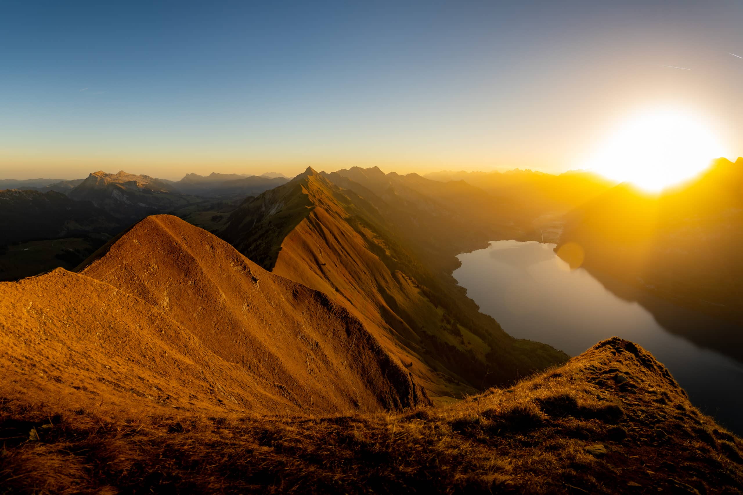
The most iconic spot is found just a 2-minute walk from Augstmatthorn summit and can be seen from the top with the cross. It offers mesmerizing views of Brienzersee from above, as well as the three majestic peaks of the Jungfrau Region – Eiger, Mönch, and Jungfrau.
Another scenic part of the trail is the whole section between Augstmatthorn and Suggiture. The trail is perched on top of a sharp ridge with stunning views on both sides. You can try a few different compositions and play with shadows.

Regarding the light, both sunset and sunrise are just spectacular. But when the sun rises, the mountains cast a huge shadow on Lake Brienz, causing the colors to fade slightly. So to combine both the golden hour colors and capture the turquoise lake, sunset might be a better option.
Frequently asked questions
While some sections are steep and slightly exposed, it’s nothing experienced kids wouldn’t manage. So if you go hiking often, you will be fine. Just keep an eye on your little ones.
Dogs are allowed both at the funicular and the hiking trail.
As mentioned above, bring enough food and water, since you won’t find any facilities on the trail. Additionally, this is no hike for regular sneakers. Proper hiking shoes with a good grip are necessary. Don’t forget to use a sunscreen.
I believe even beginners will enjoy hiking Augstmatthorn. As long as you have good shoes, you’ll be safe. We recommend hiking from Lombachalp, which is way easier.
Yes, you can hike Augstmatthorn in winter from Lombachalp. Harder Kulm funicular does not operate in winter months. Don’t forget crampons.
Best time to hike Augstmatthorn
Regarding the best time of the day, I suggest early morning. If you’re coming via Harder Kulm, take the first funicular if possible. The earlier you start, the less crowded it will be. Another advantage is that you’ll avoid the hot midday sun.
To enjoy the best views, a sunset is also a good option. We hiked Augstmatthorn for sunrise and it was nothing short of spectacular.
Make sure to check the forecast and see if the weather conditions are gonna be good.

When it comes to the best season, it’s important to note that the trail looks different in each part of the year. To see the ridge covered in lush green colors, summer is the best. In spring, there might still be some snow.
We hiked Augstmatthorn in early October. As you can see in the photos, in autumn the grass turns orange and the vibe changes completely. Winter offers a country covered in snow, but it also means more hazards due to slippery terrain.
Best activities in Interlaken
Other attractions to visit nearby
- Grindelwald – A beautiful typically Swiss town which offers many hikes, such as Bachalpsee. Adrenaline lovers will love Canyon Swing.
- Jungfraujoch – The highest train station in Europe and the main attraction of the Jungfrau region.
- Lauterbrunnen – Fairytale valley which is also home to Staubachfall, the second largest waterfall in Switzerland. Don’t skip a visit of Mürren (and Via Ferrata Mürren) and Schilthorn.
- Oeschinensee – A bit further away, but well worth the trip! This lake will take your breath away!

Final thoughts on Augstmatthorn hike
Augstmatthorn certainly deserves a spot on the list of the best ridge hikes in Switzerland. Those views are simply unbeatable! Whether it’s the incredible color of Lake Brienzsee (which I still can’t believe to be real), or the majestic peaks of the Jungfrau Region.
We also recommend visiting Lavertezzo in Valle Verzasca for another incredible experience! You can swim in the turquoise mountain river or try Europe’s highest bungee jump.
We had a truly memorable day and witnessed a sunrise we won’t forget easily. And no, it’s not because we had to freeze at the top for one hour to see the sun :D.