This article contains affiliate links. Learn more in our affiliate disclosure.
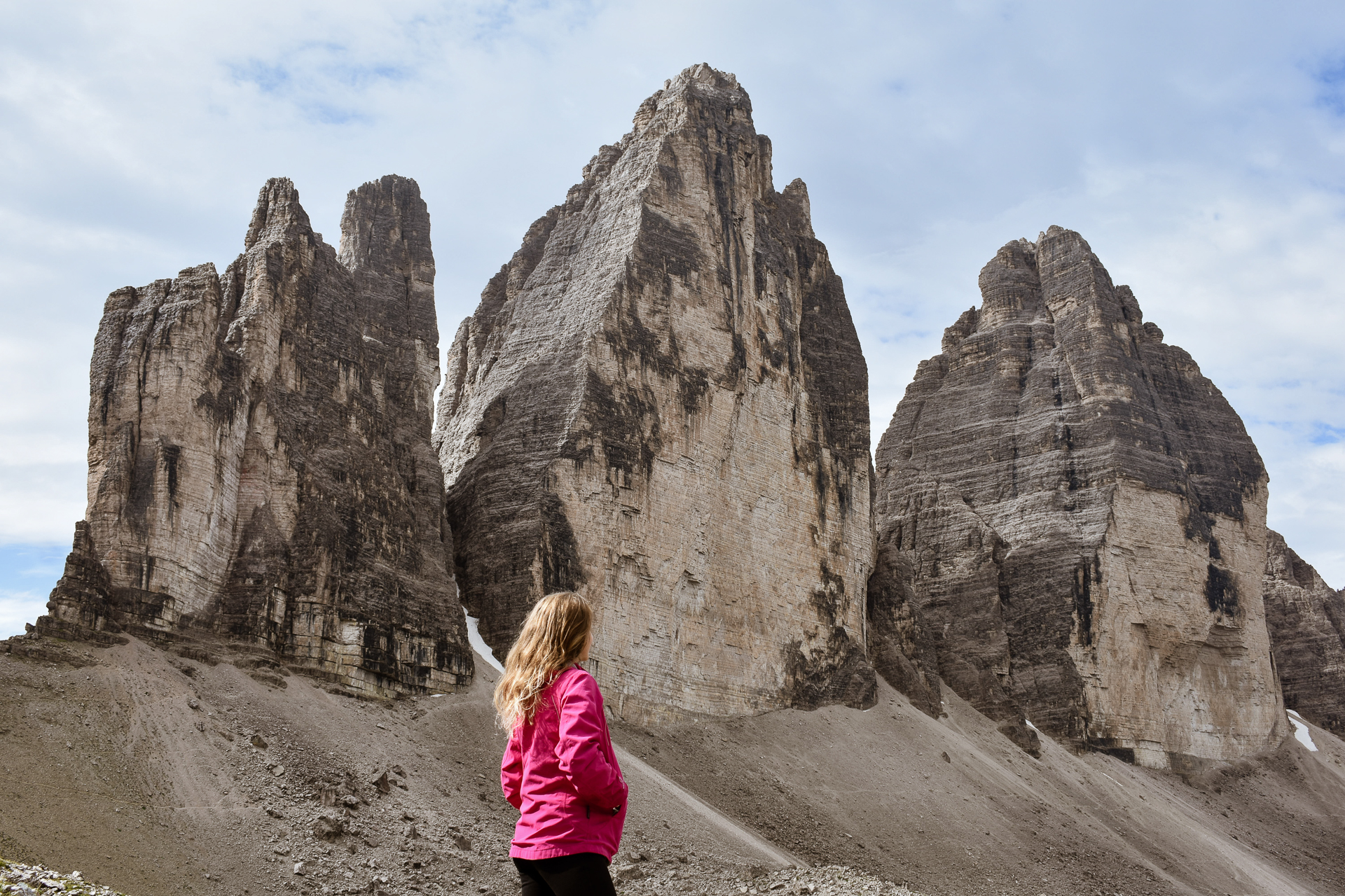
Tre Cime di Lavaredo is a must-visit hike in the Dolomites, famous for its dramatic three peaks and stunning alpine views. It’s one of those hikes that feels special no matter your experience level — perfect for nature lovers and photographers alike.
We started our day early to beat the crowds and enjoy the peaceful morning air. The weather surprised us with a short rain shower, but luckily it only lasted about an hour.
After that, we had clear skies and beautiful light for the rest of the hike. Along the way, we took a few nice detours that added extra charm to the day — I’ll share those later in the guide.
In this post, you’ll find all the practical info to plan your visit: how to get there, parking and entry rules, different hiking routes, mountain huts, and tips from our own experience.
Whether you want a quick day trip or a full loop, this guide will help you make the most of your time at Tre Cime di Lavaredo.

Key Highlights
⭐️ Best time to visit: mid-June till late October
⭐️ Starting point: Rifugio Auronzo
⭐️ Parking: mandatory reservation with 40€ road toll
⭐️ Trail number: 101, 105
⭐️ Hike duration: 4-5 hours (or more)
⭐️ Hiking distance: around 10 km
⭐️ Difficulty: medium
Quick Overview
The hike around Tre Cime di Lavaredo starts from Rifugio Auronzo, a mountain hut reachable by a private toll road with mandatory parking reservation. The toll is 40€ for cars and 60€ for campervans for 12 hours.
The most popular route follows Trails 101 and 105, which form a loop around the peaks. The hike takes about 4 to 5 hours and covers roughly 10 km in total.
The trail is rated medium, with some rocky and uneven sections, but it’s generally well-marked and easy to follow.
The best time to start the hike is early in the morning. You’ll avoid the crowds and get to enjoy peaceful views of the famous peaks.


Where is Tre Cime di Lavaredo?
Tre Cime di Lavaredo (also known as Drei Zinnen in German) is located in the Dolomites in northern Italy, right on the border between South Tyrol and the Province of Belluno. It’s part of the Sesto Dolomites.
The closest major towns are:
- Misurina – 30 minutes by car
- Cortina d’Ampezzo – about 50 minutes by car
- Dobbiaco/Toblach – 40 minutes away
If you’re looking at a map, it is right near the Austrian border and can even be seen from some spots in Austria on clear days.

Where to stay
The closest towns are:
Cortina d’Ampezzo – The best base for most hikes in the area. Plenty of hotels, restaurants, and shops. It’s only a 45-minute drive.
Misurina – A smaller, quieter option with scenic lake views. Only a 20-minute drive from the trailhead.
Best hotels near Tre Cime
Check availability


If you’d rather stay on the quieter side of Tre Cime, Naturhotel Leitlhof near Val Fiscalina is a great base. From here, it’s easy to reach the peaks from the opposite side — and you can skip the expensive parking at Rifugio Auronzo altogether. Otherwise, it’s just about a 45-minute drive if you still want to start there.
The hotel itself is a destination: a carbon-neutral mountain retreat with an incredible spa, indoor and outdoor pools, and saunas that open up to sweeping Dolomite views. We were happy to spend the rainy days enjoying the setting, and the sunsets from the pool were just incredible.

How to get there in 2025
By car (toll road & parking info)
Back then, we simply drove up in the morning, stopped at the ticket booth near the gate, and paid the toll fee (around 30€) to access the private road leading up to Rifugio Auronzo, where the main trail starts.
However, starting in 2025, this has changed due to the high number of visitors.
- The toll is 40€ per car and 60€ per campervan in 2025
- The road is only open from late June to late October, depending on snow
- Once you pay the toll, parking at the top is free
IMPORTANT: It’s now mandatory to reserve your parking slot in advance at pass.auronzo.info if you plan to drive up. The reservation gives you access for 12 hours, and you can select any starting time 24/7, depending on availability.

By public transport
You can also get there without a car, especially during the summer months.
From Dobbiaco (Toblach), there’s a seasonal bus 444 that goes directly to Rifugio Auronzo. You can also take a bus from Cortina d’Ampezzo with one transfer at Dürrensee (it takes around 1-1.5 hours).
To figure out the best route and connections, check the schedules on Südtirol Mobil or local transport sites. When planning your journey, set your final destination as Auronzo di Cadore or Auronzohütte — that’s the starting point of the trail.

If your goal is to save on parking, leave your car down in Misurina (for 14€ per day or 2€ per hour) and take either the 444 bus or Dolomiti Bus to Rifugio Auronzo. The Dolomiti Bus costs 10€ for a round trip, without an option to buy a single-ride ticket only.
There’s a ticket machine at the huge parking area in Misurina, or you can pay ONLY with a card on the bus. We didn’t make a reservation, so we ended up taking the bus and found it very convenient.
However, we found the online schedule confusing and different from reality. We recommend using Google Maps’ public transport option, which seems to be correct.
TIP: If you’re not comfortable driving or navigating buses, consider guided day tours from places like Cortina or Bolzano that include transportation — a stress-free option if you’re short on time or just want to relax and enjoy the views!


Dolomites Travel Guide
Get our complete Dolomites guide with the best hikes, hidden gems, and practical tips — all in one place.
Our travel guide includes:
🗺️ An interactive map for easy navigation
👀 95 things to do and see
🤩 6 ready-made itineraries
🥾 The best hikes and viewpoints
⭐️ Hidden local gems
📚 Practical tips for smooth travel
Tre Cime di Lavaredo hiking routes
Here’s a quick overview of your options:
- Tre Cime di Lavaredo Loop (Big Loop) – The most popular route, around 9–10 km long. This scenic loop takes you all the way around the peaks and offers the best views. Suitable for most hikers with a basic fitness level. We did this one and highly recommend it!
- Short Walk to Forcella Lavaredo – A quick 6 km hike from Rifugio Auronzo to the famous viewpoint near Rifugio Lavaredo. Great if you’re short on time or don’t want to do the full loop.
- Rifugio Auronzo to Locatelli and back – Out-and-back 9.6 km trail to the iconic Rifugio Locatelli and the famous view of the north face of Tre Cime di Lavaredo.
- Climbing & Via Ferrata Routes – For experienced adventurers, there are technical trails and via ferrata routes around the peaks. These require gear and experience.

Alternatives (if parking is full)
If the Rifugio Auronzo parking is fully booked or you didn’t manage to reserve a spot, don’t worry — there are other ways to reach Tre Cime di Lavaredo.
- Park at Lago di Misurina – And take the Dolomiti Bus up to Tre Cime.
- Hike from Lago d’Antorno – From the lake, it’s about a 1.5–2 hour uphill hike to Rifugio Auronzo. It’s an option if you’re fit and want to save on the toll.
- Trail 102 from Val Fiscalina – A scenic hike with great views. You can park at Fischleintalboden for about 15€ per day. The hike is approximately 7 km one way, with a total ascent of 960 meters.
- Trail 105 (Innerfeldtal) – You need to park further down the valley and take the shuttle bus 449 to Antoniusstein. From there, the hike to Tre Cime di Lavaredo is approximately 7.7 km one way, with a total ascent of 960 meters.

Hiking Map


Tre Cime di Lavaredo Loop – what to expect
The full loop around Tre Cime di Lavaredo is about 10 km and takes around 4–5 hours, depending on your pace and how many detours or breaks you take.
The trail is easy with a few rocky paths, and our Be Lenka Trailwalker 3.0 barefoot shoes handled it perfectly. We wore them on several hikes in the Dolomites, including Tre Cime di Lavaredo, and they performed brilliantly – light, flexible, and grippy even on uneven terrain. Honestly, one of the best barefoot pair we’ve used for mountain hikes.

We hiked for about 7 or 8 hours. I strongly recommend allocating the whole day to exploring the area if you want a relaxed experience.
If you’re looking for a spot with epic views that doesn’t require much hiking, we recommend the Seceda ridgeline. It’s easy to reach by cable car and offers one of the most iconic panoramas in the Dolomites.

Here’s what each part of the hike looks like:
Rifugio Auronzo – Rifugio Lavaredo
Finding the trailhead is not too hard. We walked behind the mountain hut and found the trail 101. There’s also a sign, but it’s hard to miss since most people are gonna be walking in the same direction.
We started the hike from Rifugio Auronzo on a wide, mostly flat, and easy path. On our right we could see the Insta-famous Cadini di Misurina, while on our left were the Tre Cime di Lavaredo from behind.

After about 15–20 minutes, we spotted a side trail on the right and decided to explore. It led us to a quiet memorial spot with incredible views — a quick and beautiful detour that only took a few extra minutes.

Back on the main path, we hiked gradually toward Rifugio Lavaredo. It was a short and easy stretch. We didn’t stop at the hut, but it’s a popular place to rest.
There are toilets available, but they were dirty and had no toilet paper, so we were glad we had tissues with us.
Forcella di Lavaredo – the first iconic view
From Rifugio Lavaredo, we climbed slightly up to Forcella di Lavaredo. This is where we got the first iconic view of Tre Cime di Lavaredo — a dramatic moment that made the hike feel instantly worth it. We paused here for photos and a quick break before continuing.

Detour to the Caves
As we reached this part, it started raining. We noticed a small cave uphill and decided to climb up to take shelter. Once inside, we discovered that the cave was part of an old military tunnel from World War I.
We explored for 10–15 minutes, walking through narrow, dark tunnels that occasionally opened to windows with views of Tre Cime di Lavaredo and other peaks. It was completely dark inside, so our phone lights were super helpful.


We met a few other tourists exploring the tunnels. I’m not sure if it’s possible to continue this way any further.
After the short detour, we hiked back down to the main trail.
Forcella di Lavaredo – Rifugio Antonio Locatelli
We continued hiking along the main path toward Rifugio Locatelli. The views kept changing, and we saw Tre Cime di Lavaredo from different angles. This stretch was one of the most scenic parts of the hike.
Once we reached the hut, we stopped for a break and soaked in the views. The hut faces Tre Cime di Lavaredo directly and has drinks, food, and water (not free). It’s also possible to stay overnight here if you book ahead.
It was pretty busy with tourists flocking in from different directions.


Detour to the Photospot
Right behind Rifugio Locatelli, there’s another short uphill trail that leads to old military tunnels. One of them frames Tre Cime di Lavaredo perfectly — it’s a famous photo spot among photographers.
We saw quite a few people heading up there, but we decided to skip it. In hindsight, I’m not sure why we were so lazy, and I’d definitely go up there next time. If you’re up for a bit more climbing, it’s worth checking out.

Rifugio Antonio Locatelli – Langalm
From the hut, we followed the trail downhill into the valley and then climbed again toward Langalm. This part felt more peaceful and less crowded. We really enjoyed this stretch — it was more relaxed, with open views all around.
But we were starting to feel tired, and the uphill walk was not too easy.

The atmosphere at Langalm was super cozy. To me personally, this hut felt the most inviting and authentic — it didn’t feel like a big tourist stop. It looked like a perfect place to relax, grab a dessert, and recharge before finishing the hike.
But since we saw another storm quickly approaching, we decided to skip the break and continued straight back to the parking lot.

The final stretch back to parking
After leaving Langalm, we hiked the final stretch back to Rifugio Auronzo. The path slowly climbed back up with some rocky sections and great views to keep us going.
We finished the hike tired but happy — it was definitely one of the highlights of our Dolomites trip.
We made it back to the car just in time before it started pouring. We had considered continuing to Cadini di Misurina, but the weather quickly changed our plans.
Instead, we drove to the parking area for the Lago di Sorapis hike, which we had planned to do early the next morning.

Tip: If you’re already exploring this area, don’t forget to visit Lago di Braies, one of the most beutiful lakes in the Dolomites.
Mountain huts
There are several mountain huts along the Tre Cime di Lavaredo trails:
- Rifugio Lavaredo is 1.7 km from the start. The toilets are paid, very dirty, and usually have no toilet paper. We didn’t eat there, but based on reviews, the food is overpriced and not very good.
- Rifugio Auronzo is better for drinks than food, which is not that great. Expect higher prices, but you can buy drinking water here.
- Rifugio Locatelli offers amazing views of the famous Tre Cime di Lavaredo peaks, good food, and the possibility to stay overnight.
- Langalm offers amazing desserts, toilets cost 1€ (free for customers), and it’s perfect to recharge before the final section.
TIP: Bring enough cash, since you can’t pay with a card. There’s also a limited signal and no wifi.

Venice is only a few hours away and pairs well with a Dolomites trip. Check out our guide to the 15 best things to do in Venice if you want to extend your trip.
Best time to visit
Best time of day
We recommend starting your hike early in the morning.
We enjoyed a sunrise at Lago d’Antorno and went up to the parking shortly after. It was perfect — quiet trails, soft morning light, and cooler temperatures.

Best Time of Year
The road to Tre Cime di Lavaredo usually opens late June and stays open until late October, depending on snow. We visited in August, and the trails were clear, huts open, and views stunning.
However, July and August can come with surprise storms, forming out of nowhere. We experienced this a few times during our trip. Always check the weather forecast before hiking and be prepared for sudden rain.
For wildflowers, visit in July. For fewer crowds and crisp autumn light, try late September or early October, though expect colder temps and shorter days.
Looking for the best lakes in the Dolomites? Don’t miss Lago di Carezza, the stunning Rainbow Lake.

Tips for the hike
- Check the weather – In July and August, storms can appear out of nowhere. We had this happen a few times—always pack a rain jacket.
- Wear proper footwear – The trail is rocky in places. Hiking shoes make it way more comfortable and safer.
- Bring snacks and water – The huts sell food and drinks, but they’re expensive and not always great. We liked having our own.
- Respect the trails – Don’t stray off marked paths, and be mindful of others enjoying the hike.
- Download the map offline – Phone signal can be weak, so it’s helpful to have the trail saved on your phone or GPS app. We use Mapy.com for the trail maps.

Facilities on the trail
Mountain Huts (Rifugios) – There are a few huts along the trail (we listed them above). They offer food, drinks, and toilets, but expect higher prices and crowds, especially in peak season.
Toilets – Only found at the huts. Quality varies, and some were very dirty when we visited. Bring your own tissues and hand sanitizer just in case.
Drinking Water – There’s no access to natural drinking water along the trail. You’ll need to bring enough with you or buy water at the huts.
Food & Drinks – Available at the huts, but often overpriced and busy. We recommend packing your own snacks and drinks to avoid queues and save money.
Rest Spots – There are almost no benches or shaded areas along the trail. If you need a break, you’ll have to sit on a rock or the ground.

What to see nearby
If you want to explore more after hiking Tre Cime di Lavaredo, here are a few spots we loved:
- Lago d’Antorno — A beautiful lake just a short drive from Tre Cime di Lavaredo. It’s peaceful and perfect for relaxing or a gentle walk.
- Lago di Sorapis — Known for its stunning turquoise water, this hike is a bit more challenging but totally worth it for the views.
- Cinque Torri — A group of striking rock formations with easy hiking trails and some history from World War I.
- Adolf Munkel Weg – One of the most scenic forest hikes in the Dolomites. This trail runs beneath the dramatic Geisler/Odle peaks and offers a mix of meadows, forest paths, and panoramic views. It’s a relatively easy and rewarding route.
These places offer different vibes and are great for adding variety to your Dolomites adventure!

FAQ
Can I camp here?
No, wild camping is not allowed in this area
Is it stroller or wheelchair friendly?
No. The trail is rocky and uneven, so it’s not suitable for strollers or wheelchairs. If you’re hiking with a baby, a proper carrier is the best option.
Are dogs allowed?
Yes, dogs are allowed on the trail. Just keep them on a leash, especially near narrow paths and around mountain huts.
Are drones allowed?
No, drones are not allowed in the Tre Cime di Lavaredo area. It’s a protected zone, and flying drones is prohibited in most of the Dolomites.

Final thoughts
Hiking around Tre Cime di Lavaredo was one of our favorite experiences in the Dolomites.
The views were absolutely stunning, and even though it’s a popular place, it still felt special. If you plan well, go early, and avoid peak season weekends, you can really enjoy the beauty of this area without the big crowds.
It’s definitely worth the visit – whether you do the full loop or just a short walk with mountain views. Just come prepared, respect the trails and nature, and take your time to enjoy it all.