This article contains affiliate links. Learn more in our affiliate disclosure.
We’ve hiked this mountain in Germany twice now, and both visits left a strong impression for different reasons. The first time felt like a peaceful hidden gem, while our most recent trip was noticeably busier — clearly word has gotten out about how special it is.
Still, even with more people on the trail, the experience didn’t lose its magic. The sweeping views over alpine lakes and rugged peaks make it one of the best hikes in Bavarian Alps.
In this guide, we’re sharing exactly what to expect based on our own visits — from routes and difficulty to practical tips that will help you plan the hike smoothly.

Key Highlights
📍Start of trail: Herzogstandbahn
🥾Distance: 1.8 km (one-way)
🕥 Duration: 1 hour
⛰️ Elevation gain: 160 m
⬆️ Maximum elevation: 1731 m
🔥Difficulty: easy
⭐️ Trail type: out-and-back
Why we think this hike is worth it?
This hike delivers the perfect balance of effort vs. reward. The trail feels adventurous enough to be exciting, yet it’s still manageable for most reasonably fit hikers.
What really makes it stand out, though, is the constant payoff — you’re not just waiting for the summit view. The scenery keeps opening up along the way, with the lakes below and Alpine peaks in the distance creating a beautiful panorama.
Another reason we’d recommend it is variety. You get forest paths, open viewpoints, a dramatic ridge section, and a summit that genuinely feels like a proper mountain top.
If you’re choosing between several hikes in this region and want one that feels memorable without being too demanding, this is easily one we’d put near the top of the list.

Herzogstand Hiking Map
When to hike
The trail stays accessible throughout the year, but the safest conditions are usually from late May to October when snow is no longer an issue. Summer tends to bring the most stable weather, though it’s also the busiest season.
Spring and autumn are quieter alternatives we personally prefer, but it’s worth knowing that snow can appear on higher sections of the route.
We started our hike in the late morning and still found it very enjoyable, with crowds that felt manageable. One thing we’d definitely keep in mind next time, though, is the midday sun. Once you’re out of the forest and on exposed sections, it can feel surprisingly intense.

Getting to the trailhead
Arrival By Car
We arrived by our own car, and getting there felt surprisingly straightforward. The roads are scenic but easy to navigate, and the trailhead area is well organized once you reach the lake.
There are two large paid parking lots near Walchensee, both clearly marked and just a short walk from the start of the hike.

Even though there’s plenty of space, they can fill up quickly — especially on sunny summer weekends — so arriving earlier is a smart move. We paid €7 for the whole day, which felt very reasonable for such a popular hiking area.
If you’re planning to rent a car for your trip, we recommend DiscoverCars because it’s one of the most transparent and reliable comparison platforms we’ve used for finding good deals.
Arrival By Public Transport
If you’re coming from elsewhere in the Alps, the easiest way to reach the trailhead is usually by combining a train ride with a regional bus connection. Trains run frequently to nearby towns, and from there buses continue toward the lake and the cable car base.
The main bus routes serving this area are lines 328 and 329, both of which stop near Walchensee and the Herzogstandbahn station.
To plan your exact route, transfers, and departure times, we recommend using the MVV Journey Planner, which shows real-time schedules and makes coordinating connections much easier.
All these trips are included in the Bayern Ticket.
These are our top hotels in Bavarian Alps we’d book again
⭐️⭐️⭐️ Hotel Das Rübezahl 4* – The most romantic stay we’ve ever had, with a spa overlooking Neuschwanstein and outstanding food. Book this if you want a memorable experience, not just a room.
⭐️⭐️ Das König Ludwig 5* – Best adult-only pick for a wellness-focused stay thanks to its huge spa, pools, and resort-style comfort after long mountain days.
⭐️ Das Graseck 4* – Choose this if you want something unique and peaceful — you arrive by private cable car and wake up surrounded by mountains.
Taking the Herzogstandbahn Cable Car
Ticket Price: adult €21 return, chidlren (6-15) €6 return
Opening hours: see official website
The cable car ride up felt like part of the adventure rather than just transport. As we climbed higher, the views kept getting better.First over the lake, then across the surrounding Alpine peaks.

The lower station is simple and easy to navigate, with a small ticket office where payment is possible by both card and cash. After buying tickets, we scanned them at the turnstiles before boarding, and the whole process was smooth and well organized during our visit.
One thing worth planning for: the cable car doesn’t run continuously. It operates on scheduled departures, so checking the timetable in advance helps avoid waiting around at the station.
Insider Tip: The Cable car closes outside the main season for scheduled maintenance. See the official website to ensure it’s in service during your planned visit.
Official Website: herzogstandbahn.de

Trail Description
Distance: 1.5 km
Elevation gain: 100m
Duration: 1 hour
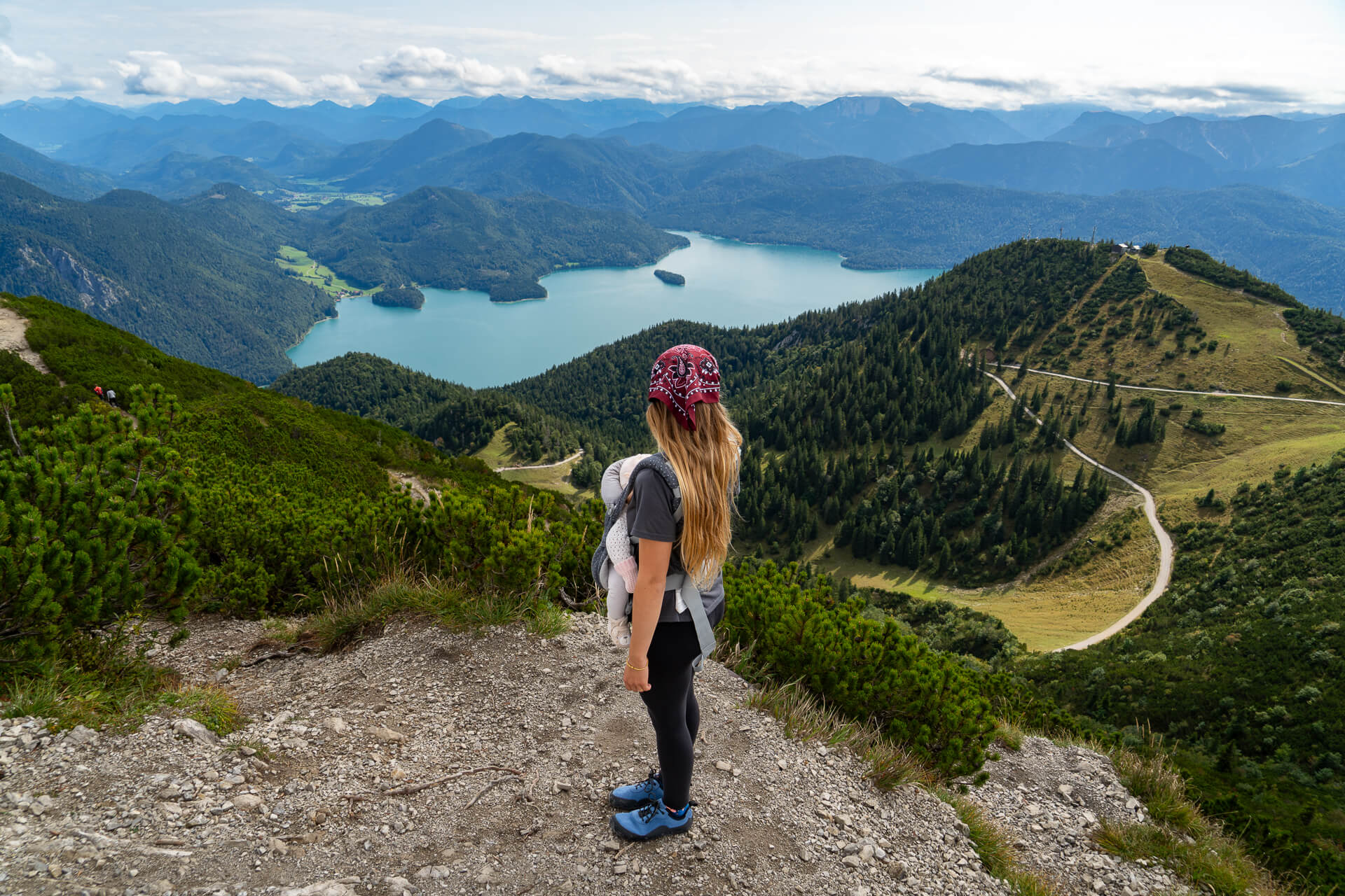
As soon as the cable car doors opened, the first thing waiting was a terrace viewpoint overlooking the striking turquoise water of Walchensee far below. The views already felt impressive from this point, and the hike hadn’t even really started yet.

The route begins along an easy, wide gravel path that traces the mountainside with open scenery almost the entire time. After just a few minutes, we reached Berggasthaus Herzogstand. Its panoramic terrace is a perfect place to pause for a coffee before heading higher.

From here, the real uphill stretch begins. The path turns rockier with loose stones, and the incline becomes steeper. Navigation is straightforward — the trail first climbs directly uphill, then the final section traverses along the slope toward the summit.
Partway up, there’s a junction with a viewpoint on the right that’s worth the short detour.


Continuing a little farther lead us to the top, where wide-open panoramas stretched in every direction. We had a clear day and could see both Walchensee and Kochelsee below, along with distant Alpine peaks including Zugspitze.

The summit area is surprisingly spacious, so even during busier times it rarely feels cramped. There’s also a small shelter building at the top, which can be a welcome refuge if strong winds roll in.
Return hike follows the same path, unless you decide to make the bigger loop through Heimgarten.


Facilities on the trail
Facilities along the hike are fairly limited. Most of the route is a classic mountain trail without shops or services, so it’s best to come prepared with enough water, snacks, and sun protection.
You’ll find a mountain hut along the way where you can rest, grab a drink, and enjoy the views from their lovely terrace. We passed it around lunchtime and it was very busy, so expect some wait time.
There’s also paid toilets at the hut and at the lower cable car station.

Trail difficulty
We’d rate this hike as easy if you combine it with the cable car both up and down. In that case, you skip most of the elevation gain and only tackle the final section to the summit, which is a bit more demanding but still very manageable.
It’s slightly steeper and rockier near the top, yet nothing felt technically difficult or intimidating to us.

The summit area itself is open and exposed, with steep drop-offs around the edges, so it’s important to stay aware of your surroundings and keep a safe distance from the cliffs — especially if it’s windy or crowded.
If you’re not used to physical activity, the uphill section might feel more challenging, but for average hikers with basic fitness, it should be completely doable and enjoyable rather than exhausting.

Skipping the cable car and hiking from Walchensee
Another option is to hike directly from Walchensee instead of taking the cable car. This route can be done as a full out-and-back hike or combined with the lift — hiking one direction and riding the cable car the other.
The trail to the summit is about 5.7 km one way, with roughly 920 meters of elevation gain, and usually takes around 3 hours to reach the top. Most of the climb passes through forest, which means shade and steady terrain but only occasional views along the way.
The scenery really starts to open up once you reach Berggasthaus Herzogstand, where the landscape suddenly shifts to wide alpine panoramas.

The alternative hike from Urfeld am Walchensee
Along the route, there’s also an alternative starting point for those who prefer to skip the cable car entirely and hike up from the valley.
This lesser-known trail begins near Urfeld am Walchensee, along the road by Kesselberg. There’s a small paid parking area nearby, making it a practical option for hikers looking for a quieter ascent.

This route is longer and more demanding than starting from the upper station. The trail covers about 7 km one way, gains roughly 880 meters of elevation, and usually takes around 3 hours uphill.
Much of the path runs through forest, which means it’s slightly less scenic than the upper sections higher on the mountain, but it does offer shade and a more peaceful atmosphere.
FAQ
Older kids who are used to hiking should be fine, especially if using the cable car. The summit area has steep drop-offs, so supervision is important.
Partially, and only until yu reach the Berggasthaus Herzogstand. However, the surface is rather bumpy, better suited for terrain strollers.
Yes — if you take the cable car up and down, the remaining walk to the summit is relatively easy and manageable for most people with basic fitness. Hiking from the lake is more demanding and better suited to those comfortable with steady uphill climbs.

Final Thoughts
This hike is one we’d happily do again without hesitation. It’s the kind of mountain that feels rewarding from start to finish. The views over Walchensee alone make it worth the trip, and once you reach the top, it genuinely feels like you’re standing at the top of the Bavarian Alps.
What we liked most is how flexible it is. It can be an easy scenic walk or a proper workout, depending on the route you choose.